FURTHER RESEARCH: INTERPRETING THE HISTORIC MINING LANDSCAPE
Although the parameters of the HAER documentation process were well defined, industrial archaeology MS student Gianfranco Archimede set out to address a line of research beyond the site documentation in conjunction with MTU/ IA faculty. While individual mining sites located in DEVA are isolated from each other, collectively they may be further understood in terms of an historic mining landscape. Expanding this perspective, considering the hundreds of similar sites throughout the Mojave Desert widens the awareness that historic cultural and industrial activity has left similar remains behind. This mining landscape is especially evident in the desert, since this vast and desolate environment quickly reveals human activity to the eye than in more lush and developed environments. In many cases, historic use of the desert involved mining, and settlement patterns followed mining activity, resulting in the now familiar ghost town scenarios associated with the American West. Archaeologists, historians, and cultural resource managers gather the documentary evidence that helps to explain the past events and people associated with these places, and can be presented as historic interpretation.
Historic landscape studies bring together this "hard" explanation of history with "softer," changing cultural values associated with the connection between people and their sense of a historic place. Landscapes are the natural settings for cultural activity that people associate with either through tradition or by personal connection, by being, living in or visiting that place. They also reflect change, representing and holding values that are remembered or forgotten, revered or replaced. The facts of historical events are consequently interwoven with an ongoing social evaluation of the past and how it connects, informs and supports people in the present. This social understanding of the past is strong enough in some cases that it takes on mythological proportions, and people sometimes arrive at historic landscapes with a variety of expectations disconnected from historical fact. Historic landscapes then, are also social destinations in the present, where history can be experienced as a sense of place. With the ongoing growth of heritage tourism in general, and increasing interest in the historic mining landscape, private owners and public land managers alike are making decisions on how to present and interpret these places and their associated ruins. This research investigates how these places are valued by the people who visit and live among them, and how these values can and do coalesce with historical fact to inform the interpretation and preservation of the historic mining landscape.
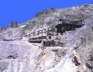
The Keane Wonder Mine is the case study site for this research. At LEFT and ABOVE are the remains of a 20 stamp mill. While the foundations are still intact, the mill structure and most machinery are gone. The large structure on the right is the lower tram terminal, where ore buckets arrived from the the upper mines via an aerial tramway and automatically unloaded into a large ore bin before heading back up. This site is easily accessed by DEVA visitors, and is a popular destination.
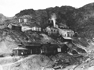
(HAER photograph by G. Archimede)RIGHT: This historic photograph of the Keane Wonder mill was taken in its first year of operation, 1908. Photos like these are invaluable in providing comparative starting points for site survey and recording, as illustrated by these two photographs.
This question calls for two types of investigation. On the one hand is establishment of "hard" historical facts on one of the sites covered in the HAER project by taking the documentation further into the realm of archaeological investigation. The chosen site, Keane Wonder, serves as an intensive case study. This turn-of-the-century gold mining site is already a popular place visited by DEVA tourists, but remains largely uninterpreted and undocumented at the larger level of archaeological detail.
On the other hand we explore the "soft" values of those who participate in valuing the mining landscape, which are collected through ethnographic and institutional research. Three groups and their associated institutions are being investigated, each connected to a specific mining landscape in the Mojave Desert. First is Keane Wonder and the overall mining landscape in DEVA, which is under the control and responsibility of the National Park Service and its mandates. At the same time, this landscape is cared for by a large non-profit group called the Death Valley 49ers, whose organizing principle rests on the promotion, celebration, and preservation of Death Valley's mining and overall cultural history. This group has been active since 1949 in donating time and money to preserve and educate others about Death Valley's history.
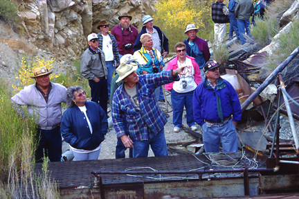
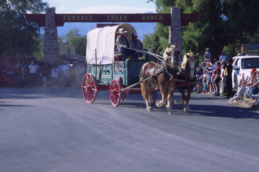
LEFT& BELOW: One of the many events at the annual 49ers encampment is a four wheel drive tour of historic Death Valley mining sites. LEFT & BELOW a 49ers group listens to a talk given during a visit to the Jail Canyon Mill site. BELOW RIGHT is a covered wagon arriving at Furnace Creek Ranch as part of a wagon train that pulls into the 49ers encampment as the settlers and miners who crossed Death Valley did in 1849. This wagon won first prize for being the most authentic of the group.
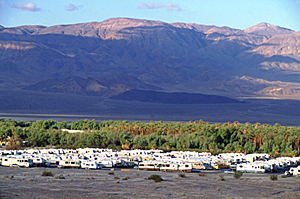
ABOVE RIGHT: One small portion of the Furnace Creek campground, where thousands of 49ers members from all parts of the country assemble every year for their annual Death Valley encampment. Although the official event is five days long, many participants extend their stay for unofficial events and to explore the park.
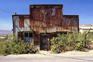
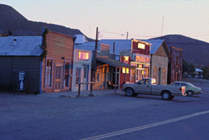
The second place considered is the gold mining town of Randsburg (1896), located in the historically famous Rand mining district south of Death Valley. Today Randsburg is a small community, self-defined as a "living ghost town," situated at the foot of a still-active gold strip mine. While mountains of waste rock and historic mining ruins dominate the landscape, many residents choose to live in Randsburg because of its historic mining character. A number of buildings on the main street have been restored, and most of those that are not restored are left intact. The town has a museum, an historical society, saloon, general store, opera house, and an inn to attract tourists who want to experience a "real" ghost town where people still live. Randsburg is an example of a how community investment and private owners come together on the level of common values to promote and preserve the Mojave's mining landscape.
Huge waste piles from current gold mining activity, TOP (left), dominate Randsburg's historic landscape today. Several buildings on the main street , LEFT, such as the the general store, are restored to their original appearance, while other historic buildings, LEFT, are left intact. Randsburg residents show appreciation for their historic surroundings by constructing elaborate lawn displays depicting mining scenes by using mining artifacts.
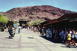
The third place investigated is Calico Ghost Town (1881), an historically successful silver mining town south of Randsburg. Calico was bought and rebuilt in the 1950s by Walter Knott of Knotts Berry Farms to resemble a ghost town for the purpose of attracting tourists. While Knott's intention was to remain faithful to historical fact, the interpretation of this landscape was more specifically focused on transmitting contemporary social values associated with the ghost town as an icon of western settlement. The town was set up to convey a sense of place for visitors to experience history in an interactive, entertaining, and a somewhat glamorous way. The whole operation was donated to San Bernardino County in 1966, and today continues to be administered by the San Bernardino Regional Parks system.
Given these three disparate examples of how mining landscapes are interpreted in the Mojave Desert, it is apparent that there are many possibilities available and many values at work. The conclusion of this project will be to apply the information derived from both the "hard" and "soft" avenues to suggest possible interpretations of the Keane Wonder site. What type of presentation can be developed to incorporate the documentary evidence with the contemporary values that bring people to these places that will faithfully explain and preserve the mining landscape? How does looking at and explaining Keane Wonder from a landscape perspective further our understanding of the connection between the past and the present?
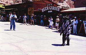
TOP RIGHT: an overview of Calico Ghost Town. Staged gunfights, LEFT / RIGHT, are an event enjoyed by many Calico tourists.
For more information, please visit these related links:
The Historic American Engineering Record
http://www.cr.nps.gov/habshaer/The Library of Congress HAER Collection
http://lcweb2.loc.gov/ammem/hhhtml/habshome.htmlDeath Valley National Park mining history http://www.395.com/deathvalley/mining.htm
The Death Valley 49ers
http://www.deathvalley49ers.org/Randsburg, A Living Ghost Town
http://www.randsburg.com/Calico Ghost Town
http://www.co.san-bernardino.ca.us/Parks/calico.htm
DEVA PROJECT & HISTORIC OVERVIEW
Email | Phone: (906) 487-2113 | Fax: (906) 487-2468